
The Laugavegur Trail, a 32.4-mile trail through Iceland’s South Highlands, can be hiked as a self-guided camping trip. Here are some tips on preparing for it!

A self-guided camping trip on the Laugavegur Trail was our introduction to backpacking in Iceland.
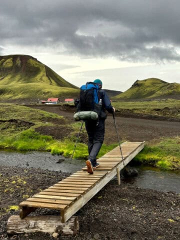
And what a journey it was! Wild weather, river crossings, fantastic vistas, and a feeling of adventure beyond what we've experienced before.
That said, the more preparation you can do for this hike, the better. The Laugavegur Trail is over 30 miles, and is often combined with the Fimmvörðuhals Trail for a 50-mile journey.
Here's what to know before you take the Laugavegur Trail as a camping trip, including thoughts about choosing a self-guided or guided hike.
Campsites Vs Huts on the Laugavegur Trail
The Laugavegur Trail is a European-style backpacking trail, meaning there are huts for rooming along the trail.
The huts are hostel-style, so they pack a lot of people into small buildings. The huts provide shelter from the temperamental Icelandic weather, and most have showers and kitchens.
The Laugavegur Trail is inside a nature preserve, and wild camping is not allowed, meaning you can’t just find a nice spot on the trail and pitch your tent. Instead, you have to camp at the hut campgrounds.
That means if you get tired and the next hut isn’t for two more miles, you just have to keep going. The good news is, we found the huts to be comfortably spaced out and the distances very manageable.
This was my first hut-to-hut backpacking trip, and I found it really nice because you’ve got access to established restrooms (usually with flush toilets). Campers can also pay to use the showers (when available). A few huts even have restaurants!
Through 2025, campgrounds did not require reservations, but huts did. This has changed as of 2026. You can book both huts and tent sites on the FI website.
Campgrounds charge a fee per person. In 2026 it costs 3400 ISK per person (about $27 USD). Check the current camping prices here.
In the past, you'd pay for camping upon arrival. Credit cards are accepted at the warden hut (the building with the i symbol). I'm unclear if that would still be an option for anyone, now that online booking is available.

Laugavegur Trail: Self-Guided Hiking vs Guided Tour
Various companies offer guided hiking tours. These are useful if you’re nervous about the trail, if you want to make reservations but they’re full, or if you don’t want to carry as much gear.
We opted for a self-guided hike of the Laugavegur Trail, where we booked our own transportation to and from the trail. We also went at our own pace instead of using a guide.
A guided tour is obviously much more expensive than a self-guided one. That said, I don’t recommend a Laugavegur Trail self-guided camping trip unless you’re very comfortable pitching tents in high winds and are an experienced backpacker.
I've also written about what gear we found best on this trail. And to get familiar with what the route is like, see my trail guide for Laugavegur.
How Many Days Should I Plan for a Self-Guided Laugavegur Hike?
The Laugavegur Trail is typically hiked in three or four days.
We hiked in four days, with nights at Hrafntinnusker, Álftavatn, Emstrur and Thórsmörk (Húsadalur, Volcano Huts). That gave us hiking days that felt very manageable for us, even in bad weather (around 7 to 10 miles per day).
We met other self-guided hikers on the Laugavegur Trail that did it in three days. They either skipped Hrafntinnusker and hiked all the way to Álftavatn on day 1, then stayed at Emstrur and Thórsmörk, or they stayed at Hrafntinnusker, Hvanngil and Thórsmörk. We thought about doing one of these routes instead, but were too tired for a 14+ mile hiking day.
Because of the distance between huts, it would be difficult to hike this trail over a longer time period, unless you're staying put and taking a zero day (a rest day).
When planning, try to build in some leeway in case you find yourself more exhausted than you anticipated. Hiking in Iceland's weather can be both physically and emotionally draining!
If you plan to add on the Fimmvörðuhals Trail, it can be hiked in either one (extraordinarily long and difficult) day, or two days. We hiked it in two days, so we were on the trail for six days, five nights total.
If you've got the time and energy, there are also day hikes in the Thórsmörk area that you could do mid-journey. We skipped those on this trip.
Should I Hike South-Bound (SoBo) or North-Bound (NoBo)?
The trail officially runs from north to south (SoBo). If you’re booking rooms in huts, they require you to hike SoBo.
With the new camping reservation system in place, it seems that campers are now also required to hike SoBo if they book multi-night packages. There do seem to be individual campsite reservations available (meaning you could technically hike SoBo), but they strongly recommend hiking NoBo.
Hiking SoBo presents a few additional challenges that NoBo hikers don't face, such as tackling the largest, fastest moving river first. Additionally, the terrain presents additional challenges (compared to NoBo), such as the long steep hike out of Álftavatn.
That said, some hikers prefer to hike SoBo, since it allows them to end their hike in Landmannalaugar with the hot springs.

Transportation To and From the Trailheads
This is a point-to-point trail, not a loop.
The trail begins at Landmannalaugar, the first hut and campground. To reach the trailhead, you travel on one of Iceland’s F roads. Traveling there requires a high-clearance 4-wheel drive vehicle capable of river crossings and a permit.
Most hikers pre-book a tour bus to the trailhead. We used Reykjavik Excursions for our bus ride. Others we know used Trex.
Side note: this is an extremely bumpy ride. If you get motion sickness, try to sit towards the front and maybe take something to prevent it. (I took Dramamine and brought ginger lozenges, but talk to your doctor if you’re not sure what to bring.)

The Laugavegur Trail officially ends in Thórsmörk, where you’ll have two different hut locations for bus pickup, either Langidalur or Húsadalur (Volcano Huts). There are extra amenities at Volcano Huts, such as glamping tents, a sauna and a restaurant, so if you’re ready for some pampering it’s a nice option.
You can pre-book a bus back to Reykjavik from either campground. (Again, I recommend Reykjavik Excursions.)
There’s also the nearby Básar campground (at the start of the Fimmvörðuhals Trail), which doesn’t have bus pickup (that I saw) but wouldn’t be a hard walk for a bus pickup at one of the other locations.
If you continue your self-guided trip further than Laugavegur, onto the Fimmvörðuhals Trail, you CAN book a tour bus (such as Reykjavik Excursions) from the end of the trail at Skógar, but the bus leaves early (usually 10:15 a.m.) and pauses in another city for about six hours, arriving in Reykjavik in the evening around 9:30 p.m. Not ideal.
We opted to take the city bus back from Skógar to Reykjavik instead. You can’t pre-book it, and there’s only one bus (so that did make me nervous), but there was plenty of room on the bus when we boarded (and it was during peak season).
Just maybe plan on arriving for the bus a bit early to ensure that there’s a spot, and to make sure you’re there in case it arrives a few minutes early.

If you opt for the city bus, take the Stræetó bus 51 from Skógar back to Reykjavik. It leaves in the afternoon (around 3:30 p.m. or 4:30 p.m. when we went, depending on if it was a weekday or weekend), and goes straight back to Reykjavik (about a two-hour drive).
We paid for the Strætó bus with a credit card when boarding and didn’t need cash. The bus ends at a city bus terminal, where you can catch another bus (or take a scooter or taxi, or walk) back to your lodging for the evening.
What Time of Year Can I Do This Hike?
Iceland’s South Highlands are only accessible in summer, typically from late June to late August or early September. The F roads leading to the trail sometimes open late and sometimes close early, depending on the weather.
The restaurant at Álftavatn sometimes opens later in the year than the huts. It was open when we visited in late July.
Staying Found on a Self-Guided Laugavegur Hike
This trail is clearly marked, and we didn’t really need our digital maps.
However, it's prone to heavy fog that makes the trail markers difficult to spot, so having a digital map is still a good idea.


If you continue onto the Fimmvörðuhals Trail, be ready for a bit more route finding, especially near the Magni and Móði volcanoes. We did check our digital maps multiple times through this section.
We carried a Garmin inReach, plus had both the AllTrails and Gaia maps downloaded. My husband’s Garmin Fenix watch did not recognize the trails; apparently he would’ve needed to download them to his Garmin app on his PC before traveling.
We also found this Knife Edge paper map and Knife Edge guidebook to be really helpful. (If I had to buy just one, I’d choose the guidebook.)
Safety in an Active Volcano Area
This trail does pass through an active volcanic area; however, the chances of one erupting with no warning signs are (I think?) slim.
At any rate, I saw a safety sign on Day 4 of our hike and thought that would've been helpful information to have at the beginning.

If an active eruption begins, hut wardens will fire maroons that emit a bang and also fire flares. If you see them go off, get to high ground immediately in an area that doesn't seem to have had lava flow in the past. (Presumably areas without black lava rock.)
Will I Have a Cell Signal?
It was actually a little shocking to me how often I had a cell signal on this trail. I was using a Síminn eSIM that I purchased from Iceland Air.
I usually kept my phone on airplane mode during the day to save battery life, so here’s what the cell phone signal situation was at each hut:
- Hrafntinnusker: No signal, I used my Garmin inReach for messages here.
- Álftavatn: 2-3 cell bars, depending on where I stood
- Hvanngil: Unsure, we hiked past and didn’t check for a signal. Fí website doesn’t mention a cell signal, so probably not.
- Emstrur: No signal at camp or in the camper shelter. Garmin inReach worked well. Fí website states you may find a cell signal “on a hill above the hut,” so maybe ask at the hut warden desk.
- Thórsmörk (Húsadalur, Volcano Huts): 3-4 bars
- Thórsmörk (Langidalur): Unsure, we hiked past without stopping. Fí website doesn’t mention a cell signal here.
- Basar: Unsure, we hiked past and didn’t check for a signal. Útivist website doesn’t mention a cell signal here.
- Baldvinsskáli (Fimmvörðuhals Trail): 2-3 bars
- Fimmvörðuskáli (Fimmvörðuhals Trail): This hut is slightly off-trail, so we didn’t pass it and don't know if there is cell service. Útivist website doesn’t mention a cell signal, but I think there may be one. Two girls we spoke to at the Baldvinsskáli hut were communicating with friends who arrived at the other hut. This hut is also more exposed than the nearby Baldvinsskáli hut. Camping here is not recommended.
- Skógar (no hut, end of Fimmvörðuhals Trail): 4 bars, full signal
Do you have any other questions about camping on the Laugavegur Trail? Leave them in the comments, and I'll do my best to help!


Logan says
Love your site. Super helpful, even after reading about the trail on several other sites! I start tomorrow!
Alisha Trenalone says
We wish you the best!!
-Alisha at Champagne Tastes